
BC Protected Areas Atlas

1
2
9
6
4
3
7
5
8
10
The numbers on the map correspond to the location of the 10 largest parks in BC, with 1 being the largest in area and 2 being the 2nd largest and so forth. The names of the ranked parks are listed in the 1st graph. BC provincial parks, ecological reserves and protected areas aswell as national parks were included in the dataset. All data is courtesy of the Province of British Columbia via various ministries and obtained via the BC data catalogue. Map and graph work was completed using ArcMap and Mircosoft Excel by Riley Smith for Geog 351 at Simon Fraser University.
The Province of British Columbia is split up into 9 different environmental administrative regions for the purposes of effectively managing the specific environmental needs of each region. The purpose of this atlas is to reveal the spatial distribution of protected environmental areas across BC and make known the coverage properties of these parks.
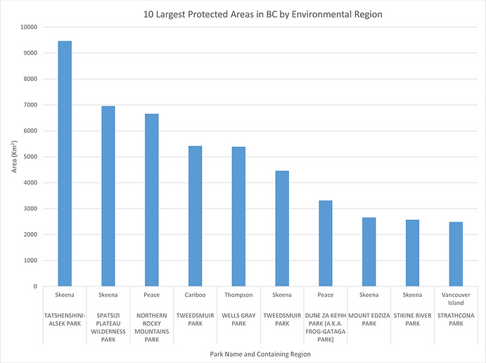
This graph shows the 10 largest parks in BC by area, all of which are designated provincial parks. 7 of the 10 are located in the 2 most northern regions of BC and half are located within the Skeena region alone. Tweedsmuir Provincial Park is actually the largest single park in the province with an area of 9878 km2, but is split into 2 by the boundary of the Cariboo and the Skeena regions creating separate parks for the purposes of this atlas.

This graph shows the regions by the percentage of area that is designated a park. Most of the regions have around at least 11% of their areas protected while only 2, the Peace region and Omineca region, have significantly less relative protected area. As you can see the Skeena region has the highest relative protected land coverage at 15.25 %.